We just returned from a long-anticipated two-week stay at our cabin on Lake Pend Oreille in northern Idaho. It was good to get away from the monsoon rains and steamy heat of the Korean summer for a short while and enjoy the sunshine, comfortable temperatures, and low humidity of the Inland Northwest. It was even better that we managed to spend a good deal of our time there up in the mountains, with packs on our backs, and a lake, mountain top, or some old mine shaft as a destination. Each time we go, we are amazed at the beauty of the mountains and the positive effect they have on our well-being. This time around, we did two hikes in the Selkirks of Idaho, two in the Bitterroots along the Idaho-Montana state line, and three in the Cabinets of Montana.
Selkirks: Pyramid, Ball, and Hunt Lakes
For the first couple hikes, we tried to acclimatize ourselves to mountain hiking again and took it easy with some short hikes to some beautiful lakes in the rugged Selkirks. While we take daily walks and runs in Seoul, we have only done a few hikes in the local mountains, being deterred by the crowds (can't escape it when you live in a city of more than 10 million) and the unfortunate fact that dogs are not allowed in Korea's national parks. So, we knew we needed a few warm up hikes before attempting to tackle longer treks into the Idaho/Montana wilderness. At the same time, we wanted the destinations to be worth while considering we had only a couple weeks and Pyramid, Ball, and Hunt lakes all met our criteria.
 |
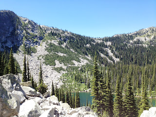
| Pyramid Lake. An easy 1-mile hike in after a long drive on a dusty forest road. We've been to this one before, but H had never been up to Ball Lakes and neither of us had been up on the crest above the lakes. |
 |
| Climbing above Pyramid Lake. |
 |
| Eight hundred feet or so above Pyramid are two more lakes, Lower and Upper Ball. This is the upper lake. |
 |
| Forces of nature above Ball Lake. |
 |
| Climb up another 5-600 feet above Upper Ball and you reach the crest of the Selkirks. |
 |
| On the Selkirk Crest with Ball Lake below. |
 |
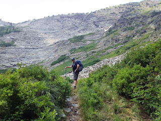
| Hunt Lake is another short hike at just a mile, but the 500-foot climb is an interesting boulder hop and not for anyone without sure feet. The drive up from Priest Lake to the trail head was long, very rough, and a pretty good work out itself. |
 |
| The "trail" to Hunt Lake. |
 |
| But there is a beautiful lake at the top. Not to far on the other
side of the saddle in the middle of the photo is Fault Lake. Check it
out here. |
Bitterroots: Hub, Heart, and Pearl Lakes
For the next couple hikes, we hit the Bitterroot Mountains that straddle the Idaho-Montana line. For anyone who has driven I-90 through western Montana and the Idaho Panhandle, you have gone through these mountains, and from the road, they may not look like anything spectacular. They are rugged, heavily forested, not very high (all under 7,500 feet), and better known for mining, logging, and the great fires of 1910. Venture into those mountains, however, and you will find massive old growth trees, picturesque high meadows, and some jewels in the form of alpine lakes.
 |
| This is one massive cedar. The stories these old trees could tell...Photos just never do justice to the real thing. |
 |
| Hub Lake. |
 |
| Hub Lake from above. |
 |
| Heart Lake. Compare this late July 2013 photo with that of this shot of the same lake on July 7th, 2011. |
 |
| Heart Lake is a relatively easy 3-mile hike, 1200-foot climb in, but the real draw is the trail that takes you up above the lake to the crest of the Bitterroots, about 1.5 miles and 1,000 feet up. The views from that trail just got better and better the higher up we went. |
 |
| And included this lovely alpine meadow. This area, the Great Burn Wilderness, was severely burned over during the Great Fire of 1910 and still bears the scars, including meadows like this one and grass-covered mountains. |
 |
| The meadows from the crest. Note our trail switch-backing up the side of the ridge. |
 |
| From the crest. Heart Lake with Pearl Lake in the background (tucked in the folds above Heart Lake). |
Cabinets: Wayup Mine, Ozette Lake, and St. Paul Lake
The Cabinets are our favorite mountains, and no trip to the area is complete without venturing into them. This time around, however, we decided to try some trails we had not hiked before, including one (Ozette) that did not appear to have a trail, but the contour lines on our topographic map suggested it would be worth finding a way in to it. Finding that way took two attempts, but the first unsuccessful try led us to a surprisingly nice destination in the form of a basin behind Lost Horse Mountain and an old gold mine.
 |
| We missed the trail head, such that it was, for Ozette, and ended up heading into this basin along an old forest road. |
 |
| Lured along by a bountiful harvest of huckleberries. |
 |
| And views such as this. |
 |
| Until we reached this point 3-4 miles in and had lunch on that huge boulder with Lost Horse Mountain in the background. The next day's destination, Ozette Lake, is on other side of the peak. |
 |
| Exploring the area behind Lost Horse Mountain. |
 |
| After the break, we climbed up a bit further to check out the remnants of what turned out to be Wayup Mine (appropriately named since we were at about 6,000 feet), an old gold mine that first operated in the 1890s and 1900s, and then again from about 1937 to the 1950s, according to Montana state records. Scattered about were mine tailings and old equipment, including the remnants of an old narrow gauge rail line. |
|
|
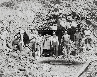 |
| And this is probably what the mine looked like when it was operational in the late 1800s. |
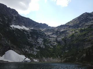
A return trip to the same area the next day was rewarded with finding the trail head to Ozette; turns out we had read our map correctly, but had simply missed it. Oh well. From our starting point, we hiked a total of about 4 miles in and gained about 2,000 feet in elevation. The trail was actually in good shape, although the last .75 miles or so was not maintained and turned into a bit of a bushwhack climb through brush and bramble and 700 feet of elevation gain. We were a little beat up once we reached the lake, but the reward was probably the prettiest and certainly one of the most dramatic of all the lakes we have seen in western Montana and northern Idaho. Ozette occupied nearly the entire cirque and was nearly completely surrounded by cliffs soaring over 1,000 feet. It was unfortunate that we got there late in the afternoon and the western sun tended to wash out most of our camera angles. Indeed, to get a true sense of the lake, one would need to climb up one of those cliff walls for a shot from above. Maybe next time.


Our last hike was to St Paul Lake, which we have looked at from the top of St. Paul peak, but never hiked in to the lake itself. At 4 miles and 1600 feet of elevation gain, it is a good day hike and quite popular. Once on the trail, one can see why as the trail winds through old growth forests of huge cedars and hemlocks and crosses several picturesque creeks. St Paul peak towers over the lake, and from the basin, one can find routes up to St Paul pass, Libby Lakes (the highest in the Cabinets at over 7,000 feet), and Isabella Lake. We had originally intended to climb up to St Paul pass for a view of one of our favorite lakes, Rock Lake, which sits nestled on the other side, but the weather failed us on this last day of hiking. Unusually for August in the Inland Northwest, it rained, and bushwhacking in the rain is not the kind of hiking we had in mind for that day, particularly not after two weeks of glorious sunshine. Still, we climbed up a few hundred feet above the lake before heading back down. We were soggy wet and tired by the time we returned to our car, but glad we got to spend our last day of hiking for the year in the Cabinets.


A rewarding hiking season. Until next year, these beautiful mountains will exist solely in our memories