Showing posts with label MT. Show all posts

Sunday, August 11, 2013

A Brief Soujourn in Idaho (Part 1): Hikes, Lakes, and Mines in the Selkirks, Bitterroot, and Cabinet Mountains


We just returned from a long-anticipated two-week stay at our cabin on Lake Pend Oreille in northern Idaho. It was good to get away from the monsoon rains and steamy heat of the Korean summer for a short while and enjoy the sunshine, comfortable temperatures, and low humidity of the Inland Northwest.  It was even better that we managed to spend a good deal of our time there up in the mountains, with packs on our backs, and a lake, mountain top, or some old mine shaft as a destination.  Each time we go, we are amazed at the beauty of the mountains and the positive effect they have on our well-being.  This time around, we did two hikes in the Selkirks of Idaho, two in the Bitterroots along the Idaho-Montana state line, and three in the Cabinets of Montana. 

Selkirks:  Pyramid, Ball, and Hunt Lakes

For the first couple hikes, we tried to acclimatize ourselves to mountain hiking again and took it easy with some short hikes to some beautiful lakes in the rugged Selkirks.  While we take daily walks and runs in Seoul, we have only done a few hikes in the local mountains, being deterred by the crowds (can't escape it when you live in a city of more than 10 million) and the unfortunate fact that dogs are not allowed in Korea's national parks.  So, we knew we needed a few warm up hikes before attempting to tackle longer treks into the Idaho/Montana wilderness.  At the same time, we wanted the destinations to be worth while considering we had only a couple weeks and Pyramid, Ball, and Hunt lakes all met our criteria.

Pyramid Lake.  An easy 1-mile hike in after a long drive on a dusty forest road.  We've been to this one before, but H had never been up to Ball Lakes and neither of us had been up on the crest above the lakes.
Climbing above Pyramid Lake.
Eight hundred feet or so above Pyramid are two more lakes, Lower and Upper Ball.  This is the upper lake.
Forces of nature above Ball Lake.
Climb up another 5-600 feet above Upper Ball and you reach the crest of the Selkirks.
On the Selkirk Crest with Ball Lake below.

Hunt Lake is another short hike at just a mile, but the 500-foot climb is an interesting boulder hop and not for anyone without sure feet.  The drive up from Priest Lake to the trail head was long, very rough, and a pretty good work out itself.
The "trail" to Hunt Lake.
But there is a beautiful lake at the top.  Not to far on the other side of the saddle in the middle of the photo is Fault Lake.  Check it out here.

Bitterroots:  Hub, Heart, and Pearl Lakes

For the next couple hikes, we hit the Bitterroot Mountains that straddle the Idaho-Montana line.  For anyone who has driven I-90 through western Montana and the Idaho Panhandle, you have gone through these mountains, and from the road, they may not look like anything spectacular.  They are rugged, heavily forested, not very high (all under 7,500 feet), and better known for mining, logging, and the great fires of 1910.  Venture into those mountains, however, and you will find massive old growth trees, picturesque high meadows, and some jewels in the form of alpine lakes.

This is one massive cedar. The stories these old trees could tell...Photos just never do justice to the real thing.
Hub Lake.
Hub Lake from above.

Heart Lake.  Compare this late July 2013 photo with that of this shot of the same lake on July 7th, 2011.
Heart Lake is a relatively easy 3-mile hike, 1200-foot climb in, but the real draw is the trail that takes you up above the lake to the crest of the Bitterroots, about 1.5 miles and 1,000 feet up. The views from that trail just got better and better the higher up we went.
And included this lovely alpine meadow.  This area, the Great Burn Wilderness, was severely burned over during the Great Fire of 1910 and still bears the scars, including meadows like this one and grass-covered mountains.
The meadows from the crest. Note our trail switch-backing up the side of the ridge.
From the crest.  Heart Lake with Pearl Lake in the background (tucked in the folds above Heart Lake).

Cabinets:  Wayup Mine, Ozette Lake, and St. Paul Lake

The Cabinets are our favorite mountains, and no trip to the area is complete without venturing into them.  This time around,  however, we decided to try some trails we had not hiked before, including one (Ozette) that did not appear to have a trail, but the contour lines on our topographic map suggested it would be worth finding a way in to it.  Finding that way took two attempts, but the first unsuccessful try led us to a surprisingly nice destination in the form of a basin behind Lost Horse Mountain and an old gold mine.

We missed the trail head, such that it was, for Ozette, and ended up heading into this basin along an old forest road.
Lured along by a bountiful harvest of huckleberries.

And views such as this.
Until we reached this point 3-4 miles in and had lunch on that huge boulder with Lost Horse Mountain in the background.  The next day's destination, Ozette Lake, is on other side of the peak.
Exploring the area behind Lost Horse Mountain.
After the break, we climbed up a bit further to check out the remnants of what turned out to be Wayup Mine (appropriately named since we were at about 6,000 feet), an old gold mine that first operated in the 1890s and 1900s, and then again from about 1937 to the 1950s, according to Montana state records.  Scattered about were mine tailings and old equipment, including the remnants of an old narrow gauge rail line.


And this is probably what the mine looked like when it was operational in the late 1800s.
A return trip to the same area the next day was rewarded with finding the trail head to Ozette; turns out we had read our map correctly, but had simply missed it.   Oh well.  From our starting point, we hiked a total of about 4 miles in and gained about 2,000 feet in elevation.  The trail was actually in good shape, although the last .75 miles or so was not maintained and turned into a bit of a bushwhack climb through brush and bramble and 700 feet of elevation gain.  We were a little beat up once we reached the lake, but the reward was probably the prettiest and certainly one of the most dramatic of all the lakes we have seen in western Montana and northern Idaho.  Ozette occupied nearly the entire cirque and was nearly completely surrounded by cliffs soaring over 1,000 feet.  It was unfortunate that we got there late in the afternoon and the western sun tended to wash out most of our camera angles.  Indeed, to get a true sense of the lake, one would need to climb up one of those cliff walls for a shot from above.  Maybe next time.


Our last hike was to St Paul Lake, which we have looked at from the top of St. Paul peak, but never hiked in to the lake itself.   At 4 miles and 1600 feet of elevation gain, it is a good day hike and quite popular.  Once on the trail, one can see why as the trail winds through old growth forests of huge cedars and hemlocks and crosses several picturesque creeks.  St Paul peak towers over the lake, and from the basin, one can find routes up to St Paul pass, Libby Lakes (the highest in the Cabinets at over 7,000 feet), and Isabella Lake. We had originally intended to climb up to St Paul pass for a view of one of our favorite lakes, Rock Lake, which sits nestled on the other side, but the weather failed us on this last day of hiking.  Unusually for August in the Inland Northwest, it rained, and bushwhacking in the rain is not the kind of hiking we had in mind for that day, particularly not after two weeks of glorious sunshine.  Still, we climbed up a few hundred feet above the lake before heading back down.  We were soggy wet and tired by the time we returned to our car, but glad we got to spend our last day of hiking for the year in the Cabinets. 


A rewarding hiking season. Until next year, these beautiful mountains will exist solely in our memories

Sunday, August 21, 2011

Cemeteries and Memorials: Windows to the past and insights into our cultures

Perhaps some will find this an odd post, but we both find cemeteries to be quite fascinating, and over the years we seem to have accumulated a considerable number of photographs of various foreign- and US-based graveyards  which we thought we might share.  No, we have no fascination with the dead, nor are we students of cemeteries, and we certainly cannot compete with the multiple blogs out there completely devoted to discussing graveyards.  Indeed, it would seem there may even be some sort of "ology" on the study of places where the dead are buried.  For us, it has  more to do with our interest in history.  An old graveyard can provide a quick introduction to a community's history and culture; natural disasters, war, epidemics, folklore, language, ethnicity, community values, and religion to name a few things that are brought to mind while one wanders amongst the headstones.   

The Ossuary at the Verdun Battlefield, France.  It contains the unidentified remains of some 130,000 French and German soldiers killed around Verdun.  Through the tiny windows along the bottom of the structure, one can view the endless piles of bones and begin to understand the magnitude of the battle. 
In the grounds to the front of the Ossuary are some 15,000 graves of identified French soldiers.  Nearly 55,000 identified German soldiers are buried in 29 cemeteries in the vicinity of Verdun.
The Meuse-Argonne American Cemetery and Memorial at Romagne, France.  It is the largest American military cemetery in Europe and contains the remains of more than 14,200 Americans, most of them killed during the Meuse-Argonne offensive.  A few have their date of death listed as 1919 and some are civilians; they probably died during the great influenza epidemic that ravaged Europe (and the globe) at the end of the war.  
In every American military cemetery, there are a more than a few unknowns.
We are not sure how an infant came to be buried here, but she likely died of the great Influenza Epidemic of 1918-1919, which killed atleast 20 million worldwide; some estimates run as high as 100 million.  Interestingly, the outbreak probably started in Kansas and was spread by US soldiers at a nearby army base who carried the virus to Europe.
A family burial tomb on Okinawa.  During the American invasion of the island in 1945, the Japanese military often used these as part of their defenses.
The "Cornerstone of Peace" on Okinawa.  These walls contain the names of more than 240,000 individuals who lost their lives during the 82-day campaign for the island.  The vast majority are Japanese or Okinawan, but some 14,000 American names are also included. 
Confederate cemetery at Franklin, Tennessee.  Almost 1,500 Confederates who died during about 3 hours of fighting at Franklin in November of 1864 are buried here.
Monuments in the Franklin cemetery honoring the dead of each Confederate state.
More questions than answers.  Driving down a dirt road while looking for a place to picnic, we found this grave in a tiny cemetery stuck way off the beaten path in the "Land Between the Rivers" (Cumberland and Tennessee rivers), Kentucky. Who killed him? Why? Were they caught and punished?
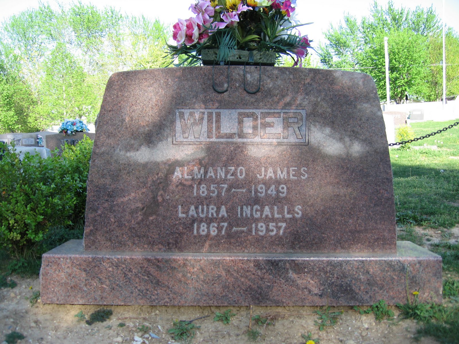
Yes, the Laura Ingalls Wilder of "Little House on the Prairie" fame.  Her grave is in Mansfield, Missouri.  H is a big fan of her books and life. 
American Cemetery at Colleville-sur-Mer, Normandy, France.  This one sits on the bluffs overlooking the invasion beach code-named "Omaha," where US forces suffered heavy casualties.   It contains the remains of 9,387 Americans, most of whom were killed during the invasion and ensuing military operations throughout Normandy. 
More from Normandy.
To rest eternally overlooking the sea... a Chinese cemetery on Hong Kong's Cheung Chau Island.
Prohibited forms of traditional ancestor worship at the cemetery on Cheung Chau Island, Hong Kong.
A missionary rests far from home in the cemetery on Cheung Chau Island, Hong Kong. She was only in her 40s. I wonder how she died.
Korean Cemetery.
Punchbowl National Military Cemetery, Hawaii.
Small family cemetery in rural North Carolina near where T grew up.  Unfortunately, it has been seriously neglected over the years, which often happens when the land containing these small family plots changes ownership.  Compare the condition of this small plot with that of the US military cemeteries.
Individual headstone from the same graveyard.  This is one of several belonging to a single family which lost two daughters and the mother in 1879.  Local lore has it that the children died of diphtheria, a common childhood illness striking thousands of victims before immunization programs came into effect.  Perhaps the mother died of a broken heart.
Wooden headstone in the same graveyard.   I would venture to guess the cedar tree behind it must be well over a 100 years old.
Just down the road from that cemetery is this small plot which also has fallen into neglect over the years.  Vandals have stolen some of the headstones from the graveyard, which dates from the 1870s.
The graveyard also holds another case where the mother and this time three of her children all died within about a year in 1885-1886.  All the children were less than 10 and this one was an infant.  Again, locals recall the children died of a diphtheria epidemic.  While I have seen no records for this particular area of North Carolina, the Journal of the American Medical Association (volume 23) says there were 131 recorded cases of diphtheria in New York City from 1885-86, with 68 deaths.  Other sources report regular and deadly outbreaks of diphtheria in the 1870s and 1880s in states as far apart as Nebraska, New Mexico, and Michigan.
Same graveyard, but this guy lived to a ripe old age.
And then there is this cemetery near the tiny town of Murray, Idaho, which provides a fascinating peek into the history of the American West.  Murray sits in the Coeur d'Alene National Forest about half way between Wallace, ID and Thompson Falls, Montana.  In other words, the middle of nowhere.  In its heyday back in the late 1800s, however, Murray was a booming little town thriving on gold and silver mining.  Many of the town's founding members now rest in the Murray Cemetery, established around 1887 and still in use.  They lay side-by-side with others who plied their trade in Murray during the boom times, including hucksters, ex-soldiers, miners, prospectors, cowboys, railroad men, and prostitutes, like Ms. McCorkendale. 
Local volunteers maintain the cemetery and have replaced some of the original headstones so the curious like us can read them.
This may be the most well known gravesite in the cemetery.  Maggie Hall was born in Dublin, Ireland and arrived in New York City in 1873.  She apparently had trouble finding work there, so Ms Hall  headed out west to seek her fortune in the mining camps and became a high-class prostitute under the name Molly Burdan.  She also became something of a local hero.  According to local lore, while on her way over Thompson Pass in the winter of 1884, she saved the life of a stranded woman and child, and during a smallpox epidemic in 1886, she organized  efforts to care for the sick. She died from complications of tuberculosis at the age of 34.
Custer Battlefield National Cemetery, Montana.  Nearly 5,000 soldiers and their dependents are buried here, representing every US conflict from the Indian War era to the Vietnam War, and they too provide some snippets about frontier life in the American West during the 19th century. Some of the more interesting individuals interred include Lieutenant William Fetterman, who bragged he could ride through the whole Sioux nation with 80 men, but when he had his opportunity, he and his 80-man command were wiped out (see Indian Wars entry, part 2);  Mrs. Julia Roach, the first woman shot by her husband in Montana Territory; Major Marcus Reno, Custer's second-in-command at the Little Big Horn, who died a friendless and broken man in 1889; three unknown soldiers from the 7th Cavalry who died at the Battle of the Little Big Horn; plus, Corporal John Noonan, who was married to a Mrs. Nash, a frontier post laundress.  In the summer of 1878 while Noonan was away from post, his wife died.  The ladies preparing Mrs. Nash's body for burial discovered she was a man.  Word soon spread over the post and poor Noonan suffered so much ridicule that he shot himself.
The cemetery also includes several hundred Indians, including White Man Runs Him, a 7th Cavalry scout who served under Marcus Reno at the Little Big Horn; he died in 1929.  The US Army made extensive use of Indian scouts during the frontier wars of the 19th century.
This nondescript cemetery in Libby, MT, at the base of the Cabinet Mountains, is included because it too tells a story.  The ore Vermiculite has been mined in the area since 1919.  Vermiculite was used in insulation produced by the Libby-based Zonolite company and was widely used in the United States in the 1950s.  Unfortunately, the vermiculite mined in the Libby area was tainted with asbestos.  In 1999, the Seattle Post-Intelligencer published a series of articles documenting extensive deaths and illness from the asbestos contaminated vermiculite at the mine.  Federal investigators subsequently found that air samples from the area had high levels of asbestos, which is suspected to have caused asbestos related ailments among former Zonolite employees and their family members.  By some estimates, more than 274 area deaths are thought to have been caused by asbestos-related diseases, and a considerable number of those still living in Libby—17 percent in one study—have various forms of diseases (primarily cancer) caused by asbestos.  Libby is now a superfund site where the US Environmental Protection Agency has been cleaning up asbestos-tainted soil and other materials since 2000.  The EPA and Department of Health and Human Services in 2008 launched an $8 million investigation into the effects of asbestos exposure on the people of Libby.  Several film documentaries and books have covered the issue, including Dust to Dust, An Air That Kills, Libby, Montana: Asbestos and the Deadly Silence of an American Corporation,  Wasting Libby: The True Story of How the WR Grace Corporation Left a Montana Town to Die (and Got Away with It), and Fatal Deception.

This memorial is in the town cemetery of St. Maries, ID.  It marks the gravesites of 78 firefighters killed during "The Big Burn" fire of 1910, which burned about 3 million acres of forest in eastern Washington, northern Idaho, and western Montana (an area about the size of Connecticut) and destroyed several small towns.  It was the largest fire in US history, and incredibly, the majority of it took place over a 2-day period (20-21 August) when the fire "blew up" and overwhelmed thousands of firefighters.
A close up of the memorial.  Timothy Egan's The Big Burn:  Teddy Roosevelt and the Fire That Saved America gives a fascinating account of the fire and its impact on the US Forest Service.  It won the National Book Award in 2009.   Stephen Pyne's Year of the Fires: The Stories of the Great Fires of 1910 is also worth a look.
Pyne's book is more of an academic study of the story of the fires, provides more detail, and is perhaps the better researched of the two, but Egan's account is more personable and lively.  For example, he provides stories of several of the individual firefighters, their actions, and their fates, including Dominick (Dominico) Bruno, an Italian immigrant who had arrived in America in 1907 and headed west in search of work.   He and his partner, another recent Italian immigrant, first worked in the copper mines of Arizona, then headed to the Pacific Northwest to fight fire because they heard the pay was good and anything would beat working in the mines.  They ended up on a firefighting crew near Wallace, ID and fought fires for 17 straight days.  During the Big Blow Up on the 20th and 21st of August, they tried to escape the conflagration by hiding in a root cellar.  They and five others were killed when the fire swept over their supposed refuge.