The language in this entry does not compare to that in H's eloquent comments on the Rock Creek Meadows hike, but I owe you a part 3 on the Indian Wars. Between Sheridan, WY and Billings, MT are the sites of two of the most famous battles of the Indian Wars on the Great Plains. The first, called the Battle of the Rosebud, is located off Montana state highway 314, about 40 miles north of Sheridan in the Crow Indian Reservation. The battle along the Rosebud River may have been the largest such fight between the US Army and the Plains Indians, involving around 2,500 combatants, but few except hardcore historians seem to know much about it. Fewer still apparently have visited the place. Approximately 50 driving miles north of the Rosebud battlefield is the site of the Battle of the Little Big Horn--also known as Custer's Last Stand--now a National Battlefield Park and probably the most famous battle of all the Indian Wars; just about everyone knows about this one.
When we last left this drive and story, the US government in 1868 had signed the Treaty of Laramie with the Lakota Sioux, Cheyenne, Arapaho, and other tribes of the Northern Plains by which a large portion of eastern Wyoming and western South Dakota was designated an Indian reservation. Washington also promised to protect the Indians "against the commission of all depredations by people of the United States."
Alas, treaties are often not destined to last, particularly when money, land, or precious metals are involved. Indeed, gold in 1874 was discovered in the nearby Black Hills, the heart of the reservation and an area considered sacred to the Sioux, and the strike attracted thousands of gold seekers hoping to get rich in violation of the treaty. The Army tried to keep them out--the level of effort is a matter of debate--and government offers to buy out the Indians also proved unsuccessful. In response, the Sioux and Cheyenne tribes began leaving the reservations and raiding White settlers, travelers, and miners in the area. By late 1875, Washington was telling the tribes to return to the reservation before 31 January 1876 or face the consequences. The Indians decided to face the consequences and the US Army was called in to resolve the situation.
The Army decided to launch three separate columns against the recalcitrant tribes. The first, under Colonel John Gibbon, would launch out of Ft. Ellis, MT (near Bozeman) and would play only a minimal role; it is not part of this blog. The second, under General George Crook, headed out from Ft. Fetterman in Wyoming Territory, while the third, under General Alfred Terry, started from Ft. Abraham Lincoln in Dakota Territory. Terry's column included the US 7th Cavalry Regiment under Lieutenant Colonel George A. Custer. The three columns planned to converge on the Indians, known to be congregating in southeastern Montana under such leaders as Sitting Bull and Crazy Horse.
Crook's column, the largest of the three, with some 1,000 cavalry and infantry plus nearly 300 Shoshone and Crow Indian allies drew first blood. On 17 June 1876, a force of up to 1,500 Sioux and Cheyenne attacked Crook's column along the Rosebud Creek. Fighting flowed back and forth across the plains, hills, and ridges above the Rosebud for six hours before the Indians withdrew from the battlefield. They inflicted about 50 casualties on Crook's force while suffering an unknown number of losses. Crook held the field, but the Indians had demonstrated a steadfastness on the battlefield not seen before and left the field confident they had won. Never had Plains Indians fought with such ferocity, and that ferocity may have shaken Crook, a decorated Civil War general, who retreated back to his base, citing concern for his wounded and a need to resupply, where he would remain for seven weeks awaiting reinforcements. As a result, he would play no role in the events that would take place about 50 miles away at the Little Big Horn.
The Rosebud Battlefield is now a state park, and while the battle encompassed area of some 10 square miles, there really isn't all that much to see outside of the creek, hills, ridges, rocky outcroppings, and the high plains of southeastern Montana. Tourists seem to have largely forgotten this battle site. Indeed, there was no one there besides me. There are few markers, and charging cavalry and horse-mounted Indians do not leave much of a trace, nor are there any "massacres," fights against overwhelming odds, or famous personalities to draw in the curious.
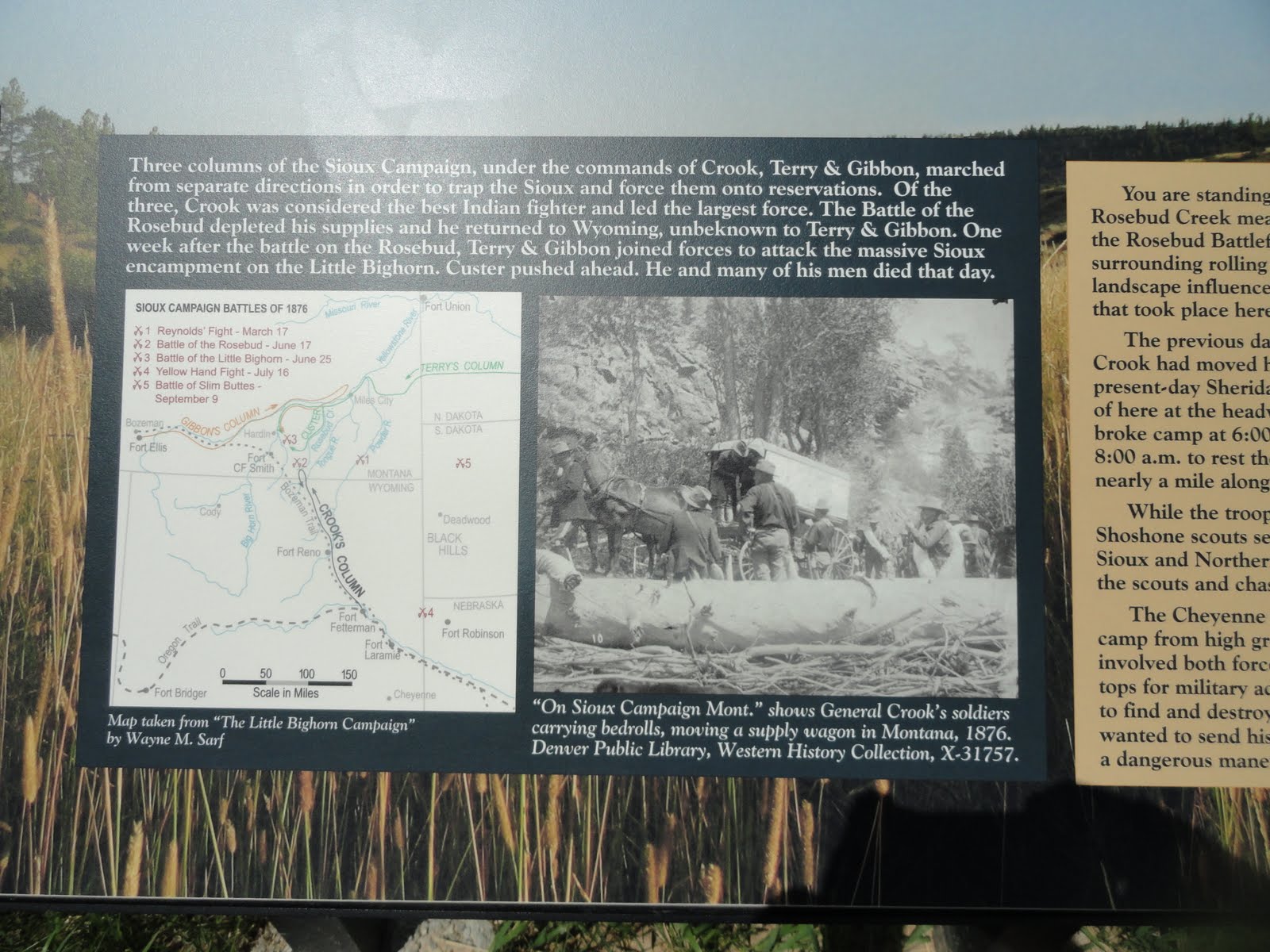
 |
| The map depicts Crook's line of march, but I was more interested in the fascinating old photo of his column on the march. |
 |
| Monument in the valley of the Rosebud. The battle started in this area |
These photos give you an idea of what the terrain was like where approximately 2,500 combatants went at it for 6 hours on a hot day in June.


The battle that took place on the bluffs above the Little Big Horn River on 25 June 1876 really needs no detailed recounting here. Suffice to say that Custer and the 600 men of the US 7th Cavalry Regiment that day ran into perhaps what amounted to the largest gathering of Plains Indians ever seen, and things did not turn out so well for a large part of the 7th. When Custer found the Indian village stretched along the valley of the Little Big Horn River, he probably underestimated its size (believed to be some 7-9,000 individuals) and the number of warriors (probably around 2,000). That might explain his decision to divide the regiment into three parts (battalions) under himself, Major Marcus Reno, and Captain Frederick Benteen, each with three separate missions. Reno's battalion attacked the camp from the south and was routed, suffering heavy casualties. The survivors fled across the river in disorder and occupied a perimeter on the bluffs above the river. In time, he was joined by Benteen's column, which had been ordered to scout off to the south to make sure the 7th was not missing any other Indian camps, and largely missed the battle. Neither went to Custer's assistance and then were put under siege for two days. In the meantime, Custer and the approximately 210 men in his battalion unsuccessfully attacked the Indian camp from the east and northeast. In the ensuing fight, he and his entire force were wiped out, leaving no white man to tell the tale of how the men died and plenty of future blame and controversy to go around. How could such a humiliating defeat have happened? Did he really just underestimate the size of the Indian camp? Was he arrogant? Was it just plain poor decision making? Did his famous luck run out? Or, as some historians have claimed, did the men of the 7th not fight very well or were they outgunned by the Indians? Did the Indians simply outfight the 7th? Were they better led?
I suspect the reason touches on several of these explanations; the experience of battle is a complicated and confusing endeavor and figuring out the whys and the whatnots are difficult even when there are multiple eyewitnesses. We will probably never know all the factors affecting the battle waged above the Little Big Horn Valley, particularly those going through Custer's head while he made his decisions as a commander of troops going into combat. History has largely been pretty hard on him, although his principle subordinates (Reno and Benteen) certainly did not serve their commander well, and "Autie" as his wife Elizabeth liked to call him, still has his supporters. Literally hundreds if not thousands of books, articles, poems, paintings, and movies over the years have tried to explain the battle and find scapegoats. Some depict Custer as an American hero fighting overwhelming odds, while others see him as a tragic figure of America's westward expansion; a few even make him out to be some sort of a metaphor for our misadventure in Vietnam. Though recent scholarship and battlefield archeology has gotten us closer to understanding how the battle played out, we will never know the details of Custer's "Last Stand," and it will continue to spark considerable debate and remain an iconic event in the history of American expansionism.
Though they won the battle, the real losers were the Indians. After the Little Big Horn the tribes scattered. The Army pursued them relentlessly, and there were no more victories; only defeat, hardship, and suffering. Most returned to the reservations or surrendered in the next few years.
As I said earlier, the Little Big Horn Battlefield is now a National Historic Monument, and an impressive one at that. The museum holds a large number of military and Indian artifacts, artwork, dioramas, and audio-visual programs dealing with the Sioux War of 1876, the battle, and the lives of soldiers and Indians. It is also a repository for a significant number of historical documents and memorabilia, including Elizabeth Custer's letters and papers, while the visitor's center has a large bookstore with an extensive number of books covering the Plains Indians Wars. The Park Service offers regular interpretive talks and walks, and one can drive the entire 5-mile length of the battle, which is well-marked and gives both a good description of the battle and a moving tribute to those who died. My only complaint is that once you enter the grounds, dogs cannot be let out of the car (why I ask?), so keep that in mind if you visit during the hot summer months--there are few trees on the high Montana plains. There are also lots of rattlesnakes. The site is surprisingly popular. I have been there several times now over the past 15 years and the park always seems to be filled with visitors from all over the United States and Canada, even considering its rather remote location. What is it that draws them? The "massacre" to speculate and debate over what really happened to Custer and his men and to pay homage to those killed? The "legend" of Custer, the flamboyant and ambitious former boy general and hero of the Civil War? The battle as a symbol of the inexorable advance of the American frontier? A chance to see the site of the last military victory of the Indian tribes over the US Army before they ultimately succumbed? Or perhaps the answer is much more simple--they are just families being dragged along by Dad. Here is a taste of what they see:
 |
| Custer artifacts. |
 |
| An impressive display of guns; that Henry rifle in the middle (the brass colored one) is worth tens of thousands of dollars. |
 |
| The Indian displays include a Sioux war bonnet and moccasins believed to have belonged to Sitting Bull, probably the most famous of the Sioux chieftains. |
 |
| Indian Memorial just behind "Last Stand Hill." |
 |
| Interior of the monument, honoring the Indian warriors who were killed during the battle. |
 |
| The Park Service in 1999 began erecting markers like this one at known Cheyenne and Lakota warrior casualty sites, just like what is done for members of the 7th Cavalry. 60-100 Indian warriors were believed killed in the battle, but there are few such markers. After the battle, families removed the dead and placed them on tipis and on scaffolds and hillsides. |
 |
| Even the horses are honored. |
 |
| Memorial atop Last Stand Hill bearing the names of the soldiers, scouts, and civilians killed in the battle. All but 11 officers, 2 civilians, and a few unknowns are buried beneath the base of the memorial in a mass grave. Including Reno and Benteen's casualties, the 7th lost about 263 killed and 52 wounded--more than 50% casualties. |
 |
| The Park Service believes this is probably the most accurate depiction of the 7th Cavalry's final perimeter. |
 |
| These headstones on Last Stand Hill mark the places where the men of the 7th Cavalry fell. They were erected in 1890 and there are 249 of them scattered about the 5 mile long battlefield. Here on Last Stand Hill is where Lieutenant Colonel George Custer and 41 others (including 2 of his brothers and a nephew) fell. The marker with the black line on it in the center is where Custer went down for those interested. I am one of those who has a rather dim view of Custer and his abilities as an officer and often wonder why the fascination with him and his life. The view in the photo by the way looks down into the valley of the Little Big Horn where the massive Indian village would have been on that fateful day in June of 1876. Between the village and the hill is what is known as the "Deep Ravine," where the bodies of many cavalry troopers were found. |
 |
| Another shot of Last Stand Hill. |
 |
| Last Stand Hill (and the visitor's center) from afar. Custer's men were driven from left to right up the slope as well as along the ridge on the right of the photo. |
 |
| Many markers lay scattered about in the ravine running from left to right across the background of this photo. Known as the "Keogh-Crazy Horse Fight," they mark the area where Captain Keogh, one of Custer's company commanders, made a stand, but he and his men were driven back, then cut down as they tried to join Custer's remnants on Last Stand Hill. |
|
 |
| Medicine Tail Ford. Part of the Indian camp (largely Cheyenne, Sans Arc, and Miniconjou) was located just across the river. Indian accounts say part of Custer's command came to the ford before being driven back to "Battle Ridge" and eventually Last Stand Hill. |
 |
| Greasy Grass Ridge. From here, Indian sharpshooters fired on 7th Cavalry troopers on the far (Battle) ridge. |
 |
| Indian accounts say one of Custer's companies tried to break up a mass of Indians here, but were driven back to the ridge in the background. Lame White Man, a Southern Cheyenne, is believed to have led the Indians here. He was later killed. To orient you, Last Stand Hill is to the left of the ridge (Battle Ridge) stretching across the horizon. |
 |
| Other 7th Cav markers. |
 |
| Site of Reno's disaster. He crossed the Little Big Horn on the left of the photo, then charged left to right towards the huge camp stretched out along the valley. Before reaching the camp, he had his men dismount and form a skirmish line across the valley as they advanced and fired. Indian warriors reacted quickly and began to outflank Reno's men, forcing them back to the timber.... |
 |
| And across the river beneath these bluffs. Having suffered heavy losses and in considerable disorder, they would scramble up the bluffs to a perimeter.... |
 |
| Here, where these Indian scouts were killed. |
 |
| Monument marking the perimeter of Reno and Benteen. They would hold out here while Custer and his men were annihilated a few miles away. |
 |
| One company commander from the Reno/Benteen perimeter, Captain Thomas Weir, led his command to this point (now called Weir Point) in an attempt to find Custer and his battalion. All they could see was a dust cloud a few miles away....and hundreds of victorious Indian warriors, fresh from annihilating Custer's command, moving towards them. Weir and his men would beat a hasty retreat back to the perimeter. |
A few books to think about if the subject matter interests you:
Sun of the Morning Star: Custer and the Little Big Horn (Evan S. Connell)
A Terrible Glory: Custer and the Little Big Horn--the Last Great Battle of the American West (Jim Donovan)
The Last Stand: Custer, Sitting Bull, and the Battle of the Little Big Horn (Nathaniel Phibrick)


Very good photos and short but clearly comments. Thank you.
ReplyDelete