T here. Long blog entry. Recently went back to the east coast and had the chance to stop off at some Civil War battlefield sites while driving to and from a conference. Three were battlefield sites around Richmond, Virginia, while the fourth was a little known river fortification in eastern North Carolina. I've been to all of them before, but not with a digital camera....
Beaver Dam Creek, 1862
The Battle of Beaver Dam Creek (or Mechanicsville), fought on 26 June 1862, was the first major engagement of the Seven Days Battles and part of the larger Peninsula Campaign, which ran from March to July of that year. Beaver Dam Creek resulted from Confederate General Robert E. Lee's attempt to turn away the advance of the Union Army of Major General George B. McClellan. McClellan's army by late June had advanced up the Virginia Peninsula to within a few miles of the Confederate capital of Richmond. Lee, having just taken command of the Confederate army defending Richmond a few weeks prior, decided to undertake a counteroffensive to drive McClellan back. His plan involved a bold attempt to turn McClellan's flank with the corps of Thomas J. "Stonewall" Jackson. To support the flank attack, another part of Lee's army, led by the division of A.P. Hill would clear the Union forces (Fitz John Porter's 5th Corps) in front of Mechanicsville, then join in with Jackson's force as it swept the Union forces south. Jackson, however, ran late. A.P. Hill, reflecting a tendency which would bear out several times during the rest of the war, grew impatient and threw his forces against the Union defenses along Beaver Dam Creek in a frontal assault. It did not go well for the Confederates. Attacking against very strong Union fortified positions along the creek, the Confederates suffered heavy casualties (1500 to Union casualties of 350) and failed to dent the Union positions. Despite the tactical victory, Union forces the next day would fall back to positions to the south, however, setting the stage for the next engagement of the Seven Days Battles, the Battle of Gaines' Mill.
 |
| Map orientation, thanks to the Park Service. The Seven Days Battles. |
 |
| Beaver Dam Creek |
 |
| Eyewitness depiction. |
 |
| Contemporary photo. |
 |
| The battlefield today. |
Gaines' Mill, 1862
Following the fighting at Beaver Dam Creek, the Union forces there fell back to a strong defensive position a few miles to the south on the high ground behind Boatswain's Creek. The Confederates followed and launched a series of disjointed attacks on the position throughout the day on 27 June. Confederate army staff work was poor and again, the vaunted Stonewall Jackson was late arriving. Confederate losses were heavy, but late in the afternoon, a somewhat coordinated assault finally broke the Union lines, causing the Union forces to withdraw south across the Chickahominy River, burning the bridges behind them. Of the Seven Days Battles, Gaines' Mill was the only clear cut Confederate tactical victory. They paid dearly, however, with nearly 8,000 casualties, mostly killed and wounded. Union losses amounted to nearly 7,000, but almost 3,000 of those were prisoners. Today, only a small portion of the battle, mostly the area around the Watt House, is preserved. Fortunately, it includes the area where the Confederate breakthrough occurred.
 |
| Map orientation. |
 |
| The Watt House. Run by a widow (Sarah Watt), the Watt plantation comprised several hundred acres and 28 slaves, producing a modest income from potatoes, grains, and livestock. |
|
 |
| Nice Park Service map showing the layout of the battlefield's terrain. The Union occupied the high ground, forcing the Confederates to attack uphill and across a creek, resulting in correspondingly high casualties. |
 |
| The grounds were heavily wooded, so it is hard to show the ground in a photo. |
 |
| Boatswain's Creek. |
 |
| Site of the breakthrough. John Bell Hood's Texas and Georgia Brigade got most of the credit, but other Confederate troops also claimed they broke through the Union lines around the same time. |
|
|
 |
| This Alabama brigade was one of those units claiming to have broken through the Union lines. |
 |
| The breakthrough came with a heavy price, however. |
 |
| Eyewitness depiction of the breakthrough. |
 |
| Union positions around the Watt House. |
 |
| Looking back in the opposite direction. The Confederates would have come from the woods on the right. |
Cold Harbor.
It is now June of 1864. Union General Ulysses S. Grant has fought Robert E. Lee from the Rapidan River all the way to the outskirts of Richmond. The two have fought major battles at the Wilderness, Spotsylvania Court House, and the North Anna. Grant's men have suffered heavy casualties (over 40,000 in less than a month's fighting). Lee's casualties are also heavy, and he can ill-afford them at this point in the war. After a few days of fighting and skirmishing to establish positions, Lee's army now occupies a 7-mile defensive line outside of Richmond. His line is thin and he has no reserves. Grant knows this and thinks he can break through with one large-scale coordinated assault. His army outnumbers Lee's by two to one. He orders that assault for 3 June. The Confederate defenses are thinly held, yes, but they are elaborate and nearly impregnable because by this stage of the war, the troops have nearly perfected the art of digging trenches and constructing defensive works. Given enough time and construction material, they can make defenses that will foreshadow what Europe will see in 1914-1918, with reinforced bunker-like positions and interlocking fields of fire . In 1864, offensive tactics have not yet adapted to these elaborate defenses. Union soldiers expect the assault to fail; many pen their names to their uniforms to make sure they can be identified. The assault is indeed a failure, and 6-7,000 Union soldiers fall, most of them in the first hour of fighting. Confederate losses are less than 1,500, mostly captured when one Union attack briefly seizes a portion of the Confederate line. Elsewhere, Union forces come nowhere near reaching the Confederate defenses. Grant earns the name of "butcher" and later writes that he regrets ordering the attack. The fighting does not end, however. Union troops dig in where they lay in many places within a few hundred yards of the Confederate lines. The lines are occupied another 9 days. Conditions are horrible. It is hot, water is scarce, the trenches are exposed, and snipers, skirmishing, and artillery take a heavy toll. By the time Grant shifts his army further south, he has suffered nearly 13,000 casualties around Cold Harbor; Lee, less than 5,000. Today, only about 300 acres of this harbinger of World War One fighting remains preserved. The area is small, but what remains are some of the best preserved Civil War field positions in Virginia.

 |
| Confederate positions, mostly of Hoke's division. Hoke's division, consisted largely of
North Carolina troops, held on its roster some of my ancestors in the
51st North Carolina Regiment. The regiment suffered almost 200 casualties at Cold Harbor, most of them during the brief breakthrough on 3 June. |
 |
| There isn't much left of this battlefield and to illustrate the point, check out the far left rear of the photo....that's privacy fence, just a stone's throw from some well-preserved Confederate positions. |
 |
| These are all Union positions, about 200 yards from the Confederate positions pictured earlier. |
 |
| US national cemetery just down the road from the trenches. |
 |
| Garthwright House, which saw fighting during the Gaines's Mill and Cold Harbor battles. |
 |
| Eyewitness sketch of fighting around the Garthwright House on 2 June 1864, courtesy of the Park Service. |
 |
| Shot of the house in 1887. |
Fort Branch
Fort Branch never saw any action. Sitting on a high bluff above the Roanoke River, it guarded a key railroad bridge over the river at Weldon, NC from 1862 until the end of the war in 1865. It also protected the construction site of the ironclad ram CSS Albemarle. The railroad bridge was a vital supply route for Confederate forces in Virginia during the entire war. The CSS Albemarle wreaked havoc amongst Union forces in 1864 and enabled Confederate forces to recapture Plymouth, NC. It was later destroyed during a Union special forces type raid (a fascinating story you might read about
here. ) At one point, modern day Fort Branch contained 8 of the original 12 cannons deployed during the war. On this late spring day of 2014, however, only one was there. Fort Branch is one of the better preserved Civil War earthwork forts that I have visited over the years. It is also in a somewhat remote area, located about two miles from the small town of Hamilton, NC and about 60 miles upriver from Plymouth. It has a website here
Fort Branch.
Sketches of the original fort.
 |
| The CSS Albemarle passing Fort Branch in 1864. |
The fort today.
 |
| Moat. |
 |
| Gun embrasures as they would have looked in the 1860s. |
 |
| 32-pounder. |
 |
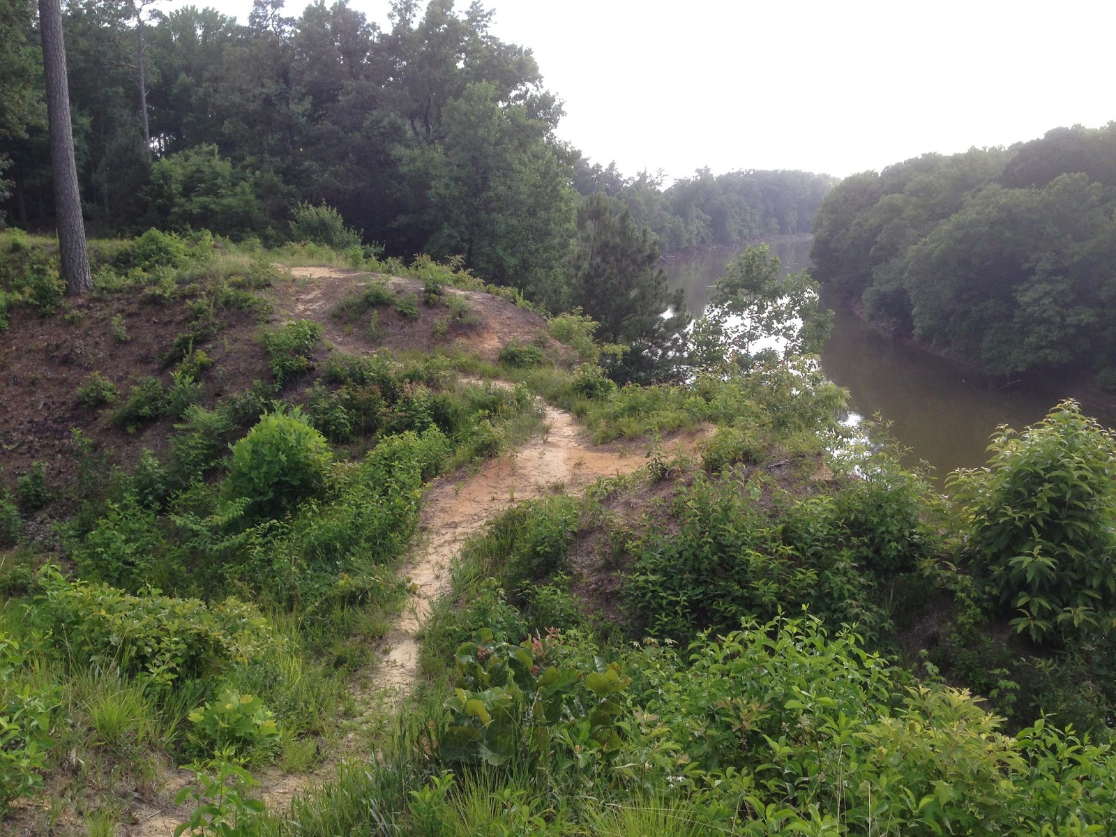
| Bluffs provide a commanding position over the Roanoke River. |


