Showing posts with label Verdun. Show all posts

Friday, January 21, 2011

Visit to the World War One Battlefield of Verdun (part deux)

Our next stop on the tour was a series of permanent French field works stretching along a ridge just west of the Meuse River.  These works allowed the French forces to cover the Meuse River valley.

Simple tributes to French soldiers who died defending these positions.


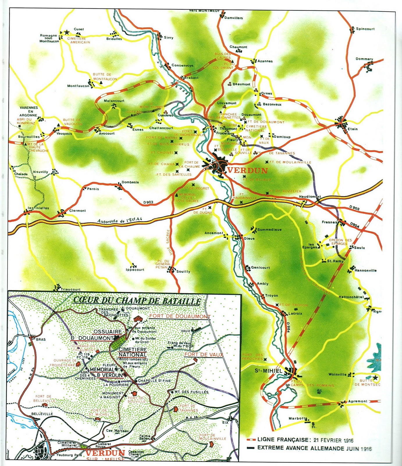
Back towards the southeast is Fort Vaux, part of the next line of French fortifications behind Fort Douaumont.  The Germans assaulted it in June, and the French defense was epic in nature.  The small garrison of 500 soldiers held on for five days against the German attacks, which included the use of poison gas and sappers with flamethrowers, fighting in the subterranean corridors from barricade to barricade.  By the third day, the garrison had run out of water and was reduced to licking the moisture from the walls and drinking their own urine. The garrison continued to fight, but surrendered 48 hours later.  One of the carrier pigeons used by the garrison to communicate with headquarters died from toxic fumes in the act of delivering its last message; the bird was posthumously awarded the Legion d'honneur and today sits in a museum on the battlefield.


 French and German soldiers fought each other for 5 days in these corridors.

 A French 75mm field gun in Vaux.  The "75" was the first modern quick-firing artillery piece and one of the best field guns of the war.

 Exterior shot of the same gun port.

More Exterior shots of Vaux. 


These next two photos show the remnants of a gun turret, destroyed by a direct hit from artillery that set off demolition charges laid by the French.  The French had intended to destroy the fort, then decided to defend it, lost it, and suffered thousands of casualties trying to get it back.


Ft. Vaux after the battle
From the German lines looking towards Vaux
With Vaux taken, only one defensive line stood between the Germans and Verdun.  This line, sitting on a ridge, included Fort Souville and the village of Fleury; if they could be seized, Verdun was doomed.  Heavy fighting raged for weeks, but repeated German attacks failed and the French held on.  Fleury changed hands 15 times and the village was totally destroyed.   The French never rebuilt the place.  Only grass, trees, monuments, plaques, and shell holes remain.  Eight other villages around Verdun were totally destroyed during the battle and never rebuilt.

Markers like these were erected to represent the business or home structure that stood on the plot before the battle.


 Aerial view of Fleury after the battle

From Fleury and Ft. Souville (which I must admit, we did not get to see because of time constraints), we headed over to the left (west) bank of the Meuse River to visit another area of heavy fighting centering around Hill 304 and Mort Homme.  The Germans were forced to assault this area early on in the battle after suffering heavy casualties from French artillery on these heights firing into the flanks of the forces attacking on the right (east) bank of the Meuse towards the defenses around Ft. Douaumont.


"They did not pass."  The monument at Mort-Homme (Dead Man) dedicated to the men of the French 69th Division who fell defending this area.  The monument shows death wrapped in a shroud holding a flag and a flaming torch. The wording is a response to Marshal Philippe Petain's declaration to the troops during the battle that, "they shall not pass."  Marshal Petain became a national hero because of his successful command of French forces defending the Verdun sector.  Later, he would be convicted for treason because of his role with Vichy France in World War Two.

The following photos are of a monument and some trenches on Mort-Homme.  German artillery fire was said to be so heavy on Mort Homme as to actually lower the elevation of the hill.  Says one author much better than I can say: "All the images of conjured up by the word 'Verdun' are to be found on Mort-Homme.  The endless bombardment, the lunar landscape, the heaps of dead, the unattended wounded, the debris, the stench, and the rats were all here on Dead Man's Hill.  After the war, the area was turned over to forestry, but the scars remain and the chaotic landscape, like a frozen sea, still bears witness to the ferocity of the shelling and the unimaginable horror of the battle."


Trenches along Dead Man's Hill and Hill 304.  The Germans suffered some 70,000 casualties trying to seize them.   These woods were in 1916 described by soldiers who fought there and portrayed by the old black and white photos of the era as a lunar landscape, devoid of vegetation, pockmarked with the imprints of thousands of shell holes, and littered with the refuse of war.  Walking through the peaceful forests in 2010, it was difficult to conceive the amount of death and destruction that men almost a 100 years ago were capable of inflicting on each other and their environment.


 This shot shows that in some areas the amount of destruction continues to affect the area.  Notice the trees are still stunted and scrub-like.  The soil absorbed so many shells that it never completely recovered.

And here are a few shots of the battlefield the way it looked in 1916:


 Very unique action shot of French troops going "over the top."  Notice the absence of vegetation in the area to their front.

As I mentioned, our trip was short; less than a day because we intended to see a little of the area of the US Meuse-Argonne offensive of 1918 before darkness set in (for another entry so stay tuned).   We missed a great deal, including the battlefield museum, Fort Souville, le bois de Caures (the start of the battle), le ravin de la mort (the valley of death)., and the Tranchee des Baionnettes (Bayonet Trench), where legend and myth has it that the remnants of a French infantry regiment still remain, buried alive under a hail of artillery fire.  Indeed, one could easily spend several days, if not a week, touring the battlefield.  We intend to go back....one day.

Thursday, January 20, 2011

Brief trip to the World War One battlefield at Verdun (part 1)

Now for some history, as in the History of Mount Needle Pie.  Get it?  :-)

Back in the Fall, we headed to Germany to see H's brother, a fighter-bomber pilot in the US Air Force.  He had just returned from a combat tour in Afghanistan, so we decided to pay him a visit.  Rather than hanging out in his home, the three of us did a driving tour through the French provinces of Alsace-Lorraine, Burgundy, and Champagne.  It was a bit of a wham-bam trip of five days, combining wine, food, typical tourist stuff, and a bit of history, plus quite a bit of driving.  A chunk of the history included a day touring the World War One battlefield at Verdun.  It was quite unlike any battlefield we've ever toured and unfortunate that we could only spend a day there.  Verdun is the French equivalent to our Gettysburg, only much, much more.  Indeed, a more appropriate comparison might be Stalingrad. 

There have been many books and other publications written on the Verdun battle, so I won't try to give you all the details.  I'll hit the highlights and focus on the areas we were able to see and photograph.  If you are looking for details, I recommend Alistair Horne's The Price of Glory:  Verdun 1916.  Written in 1962, it is highly readable for military history and remains probably the finest book on the battle.  The NY Times called it "a masterpiece."  If you want the Reader's Digest version, I recommend the Osprey Campaign Series book Verdun 1916:  "They shall not pass" written by William Martin and illustrated by Howard Gerrard. 

Verdun was one of the key battles of WW1, as well as one of the costliest in terms of casualties.  It lasted 10 months (Feb-Dec 1916) and cost the Germans and the French over 800,000 casualties, including over 300,000 killed.  When the Germans started their offensive, they intended to bleed the French Army to death; they almost did, but the German Army's own casualties ended up being almost as catastrophic.   For the French, it was to influence their post-war thinking on the defense of France against Germany and helped lead to the construction of the Maginot Line.

By 1916, all efforts by the French, British, and the Germans to break through the trenches of the Western Front had failed with tremendous casualties, but they each continued to seek a way to break the stalemate.  Based on experiences on the Russian Front, the Germans--specifically the German Chief of Staff, Erich von Falkenhayn--thought that if a major breakthrough could not be achieved, then maybe the French army could be bled to death.  Falkenhayn surmised that if the French were attacked in a position from which it could not retreat because of terrain, strategy, and national pride,  the Germans could pin the French Army in place with select infantry attacks and pulverize it with massed artillery, particularly heavy howitzers ranging in size from 150mm to the 420mm (16.5 inch) "Big Berthas." (For some perspective, a 16.5 inch gun was typically mounted on battleships and fired a shell weighing over 2,000 lbs).  Falkenhayn thought if he could select the right place on the line to attack, the French would cling to the position until it became a the death trap.  He also anticipated such tactics would provide a favorable loss exchange ratio for the German Army.  Unfortunately, the Germans will discover what many armies have discovered over the centuries; "limited" military actions often grow inexorably into larger and more costly affairs.

The ancient city of Verdun along the Meuse River was selected as the site.  The city was surrounded by a ring of forts and was so situated that losing it possibly would unhinge a large part of the French front.   The French would have to hold it.   At the beginning of the war, its forts were powerfully armed with heavy cannon and a large garrison, but the area had been a quiet sector since the early battles of 1914; consequently the French had stripped many of the forts of guns and troops to use in other parts of the line. Once the battle began, however, the French realized the sector could not be lost for both military reasons and for the sake of French honor, so they made every effort to hold the city and its surrounding forts just as the Germans predicted they would.

Map of Verdun and its forts
"Big Bertha"

The battle can be loosely categorized into phases:
1)  February-March 1916.  The initial German assault and taking of the woods (bois), heights, and villages in the vicinity of Fort Douaumont, a key fort on the heights north of Verdun.  Unexpected heavy resistance forces the Germans to expand the offensive to the left (west) bank of the Meuse River to clear their flank, leading to heavy fighting on Hill 304 and Le Mort Homme (the Dead Man hill). 
2)  April-May:  War of attrition.  The French launch unsuccessful offensive to retake Ft. Douaumont.  German attacks to clear the heights around the city continue, while their artillery continues to pulverize French defenses.  The French settle in for a long campaign, establishing the famous La Voie Sacree or "Sacred Way," a road into Verdun bringing fresh troops and supplies.  At its peak in the summer of 1916, 90,000 troops traveled the road each week and some 50,000 tons of supplies were delivered to the front.   French artillery takes a heavy toll of German forces.  The Germans are forced to bring in more troops than they originally intended.
3)  June-July:  German offensive to take the last French defenses on the heights north of Verdun, including the forts of Vaux and Souville and the village of Fleury.  Taking these heights would have enabled the Germans to fire artillery directly into the city of Verdun, cutting the bridges and forcing all French forces back across the Meuse River.  It comes close, but fails with heavy casualties. 
4)  Aug-September.  The Germans continue to try to attrite French forces, but their own losses are crippling, and they begin to see the writing on the wall.  The offensive has failed.  Their efforts weaken and the offensive is called off in September.  Artillery duels continue.
5)  October-December:  French counteroffensive retakes most of lost ground, including Douaumont in mid-October.  Local attacks continue until December.

 Progress of the German Offensive (from Osprey's Howard Gerrard)

As I mentioned, our time on the battlefield was limited, so we tried to hit the key sites, including Douaumont, Vaux, Fleury, Mort Homme, Hill 304, and a few lesser fortifications and sites.  No visit, however, would be complete without a visit to the Douaumont Ossuary.  The Ossuary contains the unidentified remains of some 130,000 French and German soldiers killed around Verdun.  Through the tiny windows along the bottom of the structure, one can view the pile of bones and begin to understand the magnitude of the battle.   The interior also is striking with its tribute to the many dead.  In the grounds to the front of the Ossuary are some 15,000 graves of identified French soldiers.  Nearly 55,000 identified German soldiers are buried in 29 cemeteries in the vicinity of Verdun.


Fort Douaumont was one of the centerpieces of the French defenses protecting the city of Verdun and is now a national monument.  The Germans seized it early in the campaign.  Its loss was a devastating blow to French morale.  One French general said it was equal to the loss of 100,000 men.  The French spent eight months trying to take it back and some 100,000 men fell in the immediate vicinity.


 Path of the German attack

 The latrines inside Douaumont.  H has never been in the army, so this lack of privacy fascinated her.

 Inner workings of the 155mm gun turret at Douaumont and the barrel.  

 Shell fragments found around Douaumont

A sample of the fort's interior

Shots of Douaumont's exterior.  Evidently, the damage to the 75mm gun turret in photo number 3 occurred during World War 2.  Other shots show the effects of the massive artillery fire that struck the fort during the battle. After the war, it was calculated the fort had been hit by at least 120,000 shells.   The next to last photo is of German troops entering the fort just after it was captured in February 1916 while the very last one shows the fort after the French retook it in October 1916.


To the south and east of Douaumont are the remnants of French communications trenches and various field works (or small forts), such as Thiaumont, which was assaulted and seized by the Germans after they captured forts Douaumont and Vaux.  Notice the dozens of shell holes.  The French did not rehabilitate the battlefield after the war, so thousands of grass- and tree-covered shell holes still remain over the entire area.  It is both stunning and unforgettable. Even for a self-proclaimed military historian, it is also difficult to get one's mind wrapped around the visual image of the incredible amount of shells and explosives that must have struck the area during the battle.


That's the end of part 1.  Stay tuned for part 2 which will look at Fort Vaux, the village of Fleury, Hill 304, and Mort Homme.